
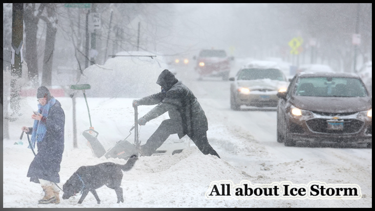
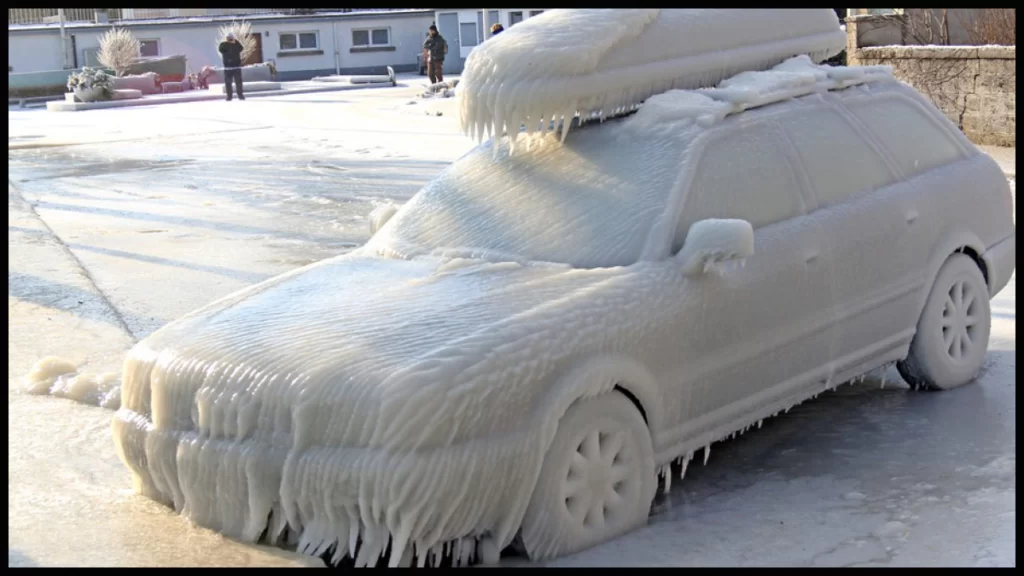
An Ice storm is a type of severe weather event that occurs when rain freezes on contact with surfaces, resulting in a coating of ice. This can cause hazardous conditions for travel and lead to widespread power outages due to fallen trees and power lines. Ice storms are most common in temperate climates, and can occur during the winter or early spring. To prepare for an ice storm, it is important to have an emergency kit that includes food, water, a heat source, and a means of communication, as well as to stay informed of changing weather conditions and any warnings or alerts issued by local authorities.
Ice storms can cause significant damage to buildings and infrastructure
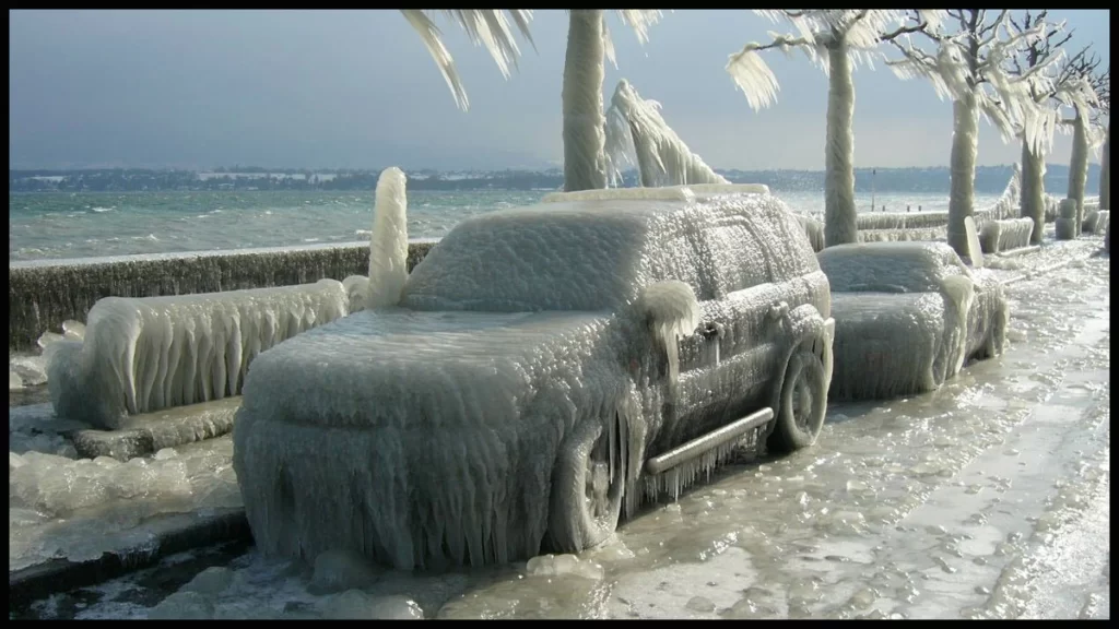
Ice storms can cause significant damage to buildings and infrastructure, and can result in major disruptions to daily life. In addition to power outages, ice storms can cause damage to roads and bridges, making travel difficult and potentially dangerous. In extreme cases, ice storms can also cause widespread flooding, as melting ice and snow cause water levels to rise.
To minimize the impact of an ice storm, it is important to take steps to prepare in advance. This may include installing storm shutters or reinforcing windows, stocking up on emergency supplies, and having a plan in place for communication and evacuation if necessary. It is also important to be aware of the potential hazards associated with ice storms, such as slipping on icy surfaces, driving on slippery roads, and being without power for an extended period of time.
If an ice storm is imminent
If an ice storm is imminent, it is important to stay informed of changing weather conditions and to take all necessary precautions to protect yourself and your property. This may include staying off the roads, avoiding travel on foot if possible, and taking measures to stay warm and dry if you lose power. By being prepared and taking the appropriate actions during an ice storm, you can help to minimize the impact of this dangerous weather event.
What happens in an ice storm?
During an ice storm, precipitation such as rain or freezing rain falls from the sky and freezes upon contact with surfaces that are below freezing temperature, such as roads, trees, power lines, and buildings. This results in a buildup of ice on these surfaces, creating hazardous conditions for travel and outdoor activities.
The ice accumulation can cause power outages
The ice accumulation can cause power outages, as heavy ice can weigh down power lines and cause them to snap. It can also damage trees and cause them to fall, which can result in further power outages and blockages on roads. The ice can also make roads and sidewalks slippery, creating a risk of slipping and falling.
In addition, the weight of the ice accumulation can cause damage to buildings, such as collapsing roofs or breaking windows. This can result in property damage and potential injury to those inside the building.
It is important to stay informed of weather conditions and to take appropriate precautions during an ice storm, such as staying off the roads, avoiding travel on foot if possible, and having an emergency kit with food, water, and a heat source.
What is the definition of an ice storm?
An ice storm is a type of winter weather event characterized by freezing precipitation that falls from the sky and accumulates on the ground, trees, power lines, and other surfaces. This precipitation may include freezing rain, sleet, or snow, and can result in a buildup of a layer of ice on these surfaces. Ice storms can cause widespread power outages, damage to buildings and infrastructure, and hazardous travel conditions due to slippery roads and sidewalks. They are most common in temperate climates and can occur during winter or early spring.
How rare is an ice storm?
The frequency of ice storms varies depending on location and climate. In some regions, ice storms can be relatively common occurrences, particularly in areas with temperate climates that experience frequent winter weather. In other regions, ice storms may be rarer, occurring only once or twice in a decade.
The frequency of ice storms can also be influenced by other factors, such as the severity of winter weather, the amount of precipitation in a given area, and the temperatures at which precipitation falls. For example, areas with particularly cold and harsh winters may experience more frequent or severe ice storms than areas with milder climates.
Overall, the rarity of ice storms is dependent on a combination of geographical location, climate, and other weather-related factors. It is difficult to make generalizations about the frequency of ice storms, as they can vary greatly from one region to another.
What caused the 1998 ice storm?
The 1998 ice storm was a major weather event that affected a large portion of eastern North America, including parts of Canada and the United States. The storm was caused by a series of low pressure systems that brought warm, moist air from the Gulf of Mexico into a region of cold air over the northeastern United States and southeastern Canada. As the warm air rose and cooled, precipitation fell in the form of freezing rain, sleet, and snow, and accumulated on the ground, trees, and other surfaces as a layer of ice.
The storm caused widespread power outages
The storm caused widespread power outages, damage to buildings and infrastructure, and hazardous travel conditions. In some areas, the weight of the ice accumulation caused trees and power lines to snap, resulting in further disruptions and damage. The storm was one of the most severe ice storms on record in the affected region, and its impact was felt for several weeks as cleanup and recovery efforts continued.
What are the 4 types of storms?
There are several types of storms, including:
- Thunderstorms: Storms characterized by thunder, lightning, heavy rain, and strong winds.
- Tornadoes: A rapidly rotating column of air that forms within a thunderstorm and can cause significant damage on the ground.
- Hurricanes: Large rotating storms that form over tropical waters and can bring strong winds, heavy rain, and storm surges to coastal areas.
- Winter Storms: Storms that occur during the winter months and can bring a variety of precipitation, including snow, sleet, and freezing rain, as well as strong winds and cold temperatures.
What is the strongest storm type?
It is difficult to determine the “strongest” type of storm as each type of storm has its own unique characteristics and hazards, and the strength of a particular storm can vary widely.
For example, hurricanes can bring extremely strong winds, heavy rain, and significant storm surges, making them one of the most dangerous types of storms. Tornadoes can also be extremely dangerous, with winds that can reach hundreds of miles per hour and cause widespread destruction in a short amount of time.
On the other hand, winter storms can bring heavy snow, strong winds, and low temperatures that can result in significant disruptions to daily life and potentially dangerous conditions, particularly for those who are unprepared or vulnerable.
In short, the strength of a storm depends on a number of factors, including its size, speed, intensity, and the specific hazards associated with that type of storm. The strength of any given storm should be evaluated based on the specific conditions and hazards it presents, rather than simply comparing it to other types of storms.
What is the strongest storm on Earth?
The strongest storm on Earth is typically considered to be a Category 5 hurricane, which is the highest classification on the Saffir-Simpson Hurricane Wind Scale. A Category 5 hurricane is defined as having maximum sustained winds of 157 miles per hour (252 km/h) or higher.
Such storms can cause widespread devastation and bring catastrophic damage to coastal areas, with strong winds that can destroy buildings, uproot trees, and cause widespread power outages. They can also bring intense rainfall, which can result in flash floods and landslides, as well as storm surges that can inundate coastal communities.
It is important to note that the strength of a storm is not the only factor that determines its impact and the level of danger it presents. Other factors, such as the storm’s size, speed, and trajectory, as well as the populations and infrastructure in its path, also play a role in determining the overall impact of a storm.
Which Clouds mean Danger?
Certain cloud formations can indicate the potential for dangerous weather conditions. Some of the cloud types that are often associated with dangerous weather include:
- Cumulonimbus clouds: Large, towering clouds that can indicate the presence of thunderstorms. These clouds can bring heavy rain, hail, lightning, and strong winds.
- Mammatus clouds: Pouch-like clouds that can form in association with severe thunderstorms or tornadoes. The presence of mammatus clouds can indicate the potential for dangerous weather conditions, including strong winds, hail, and tornadoes.
- Wall clouds: Low, rotating clouds that can form along the leading edge of a thunderstorm. Wall clouds can indicate the presence of strong winds and the potential for tornadoes.
It is important to remember that cloud formations are just one aspect of weather and that other factors. Such as temperature, wind speed and direction, and atmospheric pressure. Also play a role in determining the potential for dangerous weather conditions. Additionally, it is always a good idea to stay informed about the weather forecast. And to take appropriate precautions if dangerous weather is expected in your area.
What are snake clouds?
Snake clouds, also known as Kelvin-Helmholtz clouds. And are a type of cloud formation that can appear as undulating or “snake-like” patterns in the sky. They occur when there is a large difference in wind speed or direction between two air masses. Such as between a layer of fast-moving air at the top of a cloud layer and a layer of slower-moving air below.
The difference in wind speed creates a wave-like pattern in the cloud layer. And with the cloud appearing to break apart and form the distinctive “snake-like” shapes. Snake clouds are most commonly seen in fair-weather cumulus clouds. But can also occur in other types of clouds, such as stratocumulus or altocumulus clouds.
While snake clouds can be visually striking, they do not typically indicate the presence of any dangerous weather conditions. However, they can be a sign of atmospheric instability and indicate that weather conditions may be changing or deteriorating.
What cloud is the darkest?
The darkest cloud is typically considered to be the cumulonimbus cloud. Cumulonimbus clouds are large, towering clouds that can reach heights of up to 60,000 feet (18,000 meters) or more. They are often associated with severe thunderstorms and can bring heavy rain, hail, lightning, and strong winds.
Cumulonimbus clouds can appear very dark, particularly when they are viewed against a lighter background, such as a clear blue sky. This is because the clouds are so tall and dense that they can block out a significant amount of light. Also making the sky appear much darker in the vicinity of the cloud.
It is important to remember that while cumulonimbus clouds can be an indicator of dangerous weather conditions. And they are just one aspect of weather and that other factors, such as temperature, wind speed and direction. And atmospheric pressure, also play a role in determining the potential for dangerous weather conditions.
What is the Darkest Cloud in the world?
It is difficult to say which is the darkest cloud in the world. And as cloud darkness can vary greatly depending on the time of day, location, and weather conditions. However, cumulonimbus clouds are often considered to be some of the darkest clouds due to their large size, height, and density. These clouds can form tall towers that can reach heights of up to 60,000 feet (18,000 meters). Or more and can block out a significant amount of light, making the sky appear very dark in the vicinity of the cloud.
It is also worth noting that clouds can appear darker or lighter depending on the angle of the sun. The atmospheric conditions, and the presence of other clouds or atmospheric phenomena. So while cumulonimbus clouds are often considered to be some of the darkest clouds. The title of “darkest cloud in the world” may be a dynamic and constantly changing distinction.
What are Popcorn Clouds?
Popcorn clouds are a type of cloud formation that are characterized by their small, round, and fluffy appearance. They are often seen in the sky on fair weather days and can resemble the white. Also puffy appearance of popped popcorn.
Popcorn clouds are a type of cumulus cloud. And are formed when pockets of warm air rise from the ground and reach an altitude where the air temperature is below its dew point. At this point, the water vapor in the air condenses into tiny water droplets. And forming the characteristic “popcorn” appearance of the clouds.
Popcorn clouds are generally not associated with any dangerous weather conditions. But they can indicate atmospheric instability, particularly if they start to grow and become more organized. Also which could be an indication of the development of thunderstorms. However, in most cases, popcorn clouds are simply a visually striking aspect of fair weather and do not indicate the presence of any significant weather concerns.
What are finger clouds?
Finger clouds, also known as fallstreak holes or hole punch clouds, are a type of cloud formation that can appear as circular gaps or “holes” in clouds. They are formed when the water temperature in a cloud layer is below freezing. But the water droplets have not yet frozen into ice crystals.
When a plane flies through the cloud layer. The disturbance created by the plane’s engines can cause the supercooled water droplets to freeze and form ice crystals. These ice crystals then grow and fall out of the cloud. And leaving a circular gap or “hole” in the cloud layer.
Finger clouds can be visually striking
Finger clouds can be visually striking and are often seen from the ground as a series of circular gaps in the clouds. They are most commonly seen in cirrocumulus or altocumulus clouds and can indicate the presence of severe weather conditions. Such as turbulence or icing, in the vicinity of the clouds. However, in most cases, finger clouds are simply a fascinating weather phenomenon and do not indicate the presence of any significant weather concerns.
What is a lightning snake?
A lightning snake, also known as a positive lightning channel, is a type of lightning that occurs in thunderstorms. Unlike typical lightning, which moves from the cloud to the ground, positive lightning moves from the ground to the cloud. Positive lightning is much less common than negative lightning, but it can be much more intense and dangerous.
A lightning snake refers to the visual appearance of a positive lightning channel as it moves through the sky. Positive lightning channels can be much longer than typical lightning channels and can snake through the sky for several miles. Also giving the appearance of a bright, snake-like lightning bolt.
Because positive lightning is much less common and can be more intense and dangerous than typical lightning. And it is important to take precautions when severe thunderstorms are in the area. This can include staying indoors, avoiding contact with electrical conductors. And avoiding open areas where you may be the tallest object.
Can you ever touch a cloud?
No, you cannot touch a cloud because clouds are made up of tiny water droplets or ice crystals that are suspended in the atmosphere. Clouds are not solid masses that you can touch or walk on. They are simply collections of water vapor or particles that are held in the air by air currents.
When a cloud is thick enough and the water droplets or ice crystals are large enough. And you may feel like you are surrounded by the cloud and that it is close to you. But you cannot physically touch or interact with the cloud itself. The water droplets or ice crystals that make up a cloud are so small and diffuse that they cannot be seen or felt individually.
How rare is a Rainbow Cloud?
Rainbow clouds, also known as iridescent clouds. These are a type of cloud formation that is characterized by their iridescent or rainbow-like appearance. These clouds are relatively rare and are formed when the sun is shining behind the cloud. Also causing the light to scatter and produce a rainbow-like effect.
The rarity of iridescent clouds depends on the conditions necessary for their formation. Which include a particular type of cloud, the angle of the sun. And the presence of small water droplets or ice crystals of a similar size. These conditions are not common, so iridescent clouds are typically considered a relatively rare phenomenon.
However, iridescent clouds are becoming more commonly observed due to the increased awareness of their existence. And the ability to share photos and videos of these clouds on social media. As a result, iridescent clouds are likely to be seen more frequently in the future. Although they will still likely remain a relatively uncommon sight in the sky.
Do Blue Clouds exist?
Yes, blue clouds do exist. Clouds can appear blue when viewed from the ground due to the way light is scattered by the tiny water droplets or ice crystals that make up the cloud.
When the sun is shining on the cloud, the light from the sun is scattered in all directions. Blue light has a shorter wavelength than other colors, so it is scattered more easily than the other colors. This causes the cloud to appear blue to the observer on the ground.
It is important to note that not all clouds appear blue. The color of a cloud can vary depending on the type of cloud. The angle of the sun, and other atmospheric conditions. Some clouds may appear white, gray, or even orange or red under different conditions. The color of a cloud can also change as the sun moves across the sky and the angle of the sun changes relative to the cloud.
Who is God snake?
“God Snake” is a relatively vague term and could refer to different things in different cultures or contexts. In some cultures or religious beliefs. A “God Snake” may refer to a deity that is represented in the form of a snake. In other contexts, it may refer to a legendary or mythical serpent-like creature that is associated with power or divinity.
Without more context or information, it is difficult to provide a specific answer to this question. If you could provide more information or clarify the context in which you are asking about “God Snake,” I may be able to provide a more accurate response.
Is the Rainbow Snake real?
“Rainbow Snake” could refer to different things depending on the context and cultural beliefs. In some cultures and beliefs, a Rainbow Snake is a legendary or mythical creature that is associated with rain, water, and the rainbow. These beliefs and legends often vary greatly across different cultures and regions.
However, from a scientific perspective, there is no evidence of a Rainbow Snake as a real, physical species. Snakes are not known to exhibit rainbow-like colors or patterns. And there is no scientific explanation for the existence of such a creature.
It is important to remember that many legends, myths. And religious beliefs often include supernatural or imaginary creatures that are not based on scientific evidence. While these beliefs and stories can be an important part of a culture or community. They should not be taken as scientific fact.
What is a diamond snake?
“Diamond Snake” is a term that is not commonly used and its meaning is unclear. It is possible that the term “Diamond Snake” refers to a snake with diamond-like markings or scales, or a snake made of diamonds. However, without more context or information, it is difficult to provide a specific answer to this question. If you could provide more information or clarify the context in which you are asking about “Diamond Snake.” I may be able to provide a more accurate response.
Are Triple Rainbows rare?
Triple rainbows are relatively rare, but not extremely so. A triple rainbow is formed when the light from the sun is reflected, refracted. And dispersed by raindrops in the atmosphere three times, resulting in three concentric arcs of color in the sky. The innermost arc is the brightest and most colorful, while the outer arcs are fainter and less distinct.
While triple rainbows are not as common as single rainbows, they can be observed under the right conditions. To see a triple rainbow, the observer must be positioned in such a way that the light from the sun is able to pass through the raindrops three times and form three distinct arcs in the sky. This typically requires the observer to be positioned below the rainbow. And also looking up into the sky, so that the raindrops are between the observer and the sun.
However, even under the right conditions, it can still be challenging to see a triple rainbow. As the outer arcs are often faint and difficult to distinguish. In addition, the conditions required for a triple rainbow to form are somewhat specific. And not all rainstorms will produce a triple rainbow. Despite this, triple rainbows can be a beautiful and awe-inspiring sight for those who are lucky enough to see one.
Also Read – All about Federal Reserve
What is a moonbow rainbow?
A moonbow, also known as a lunar rainbow. The Rainbow is a rare type of rainbow that is formed when the light of the moon is refracted and dispersed by raindrops in the atmosphere. Unlike a traditional rainbow, which is formed by the sun’s light. A moonbow is formed by the light of the moon and is therefore much fainter than a sun-lit rainbow.
To see a moonbow, the observer must be positioned under the light of the moon and looking towards the opposite direction of the moon. The moonlight must then pass through raindrops in the atmosphere. And which will refract and disperse the light into its individual colors, forming a faint rainbow in the sky.
Moonbows are often described as white or pale in color. As the human eye is less sensitive to the different colors of light in low light conditions. However, with a camera or long exposure, the different colors of a moonbow can be captured and appear more distinct.
Moonbows are rare, as they require specific conditions in order to form. The moon must be at a low angle in the sky. And there must be enough rain to produce the necessary raindrops for the light to be refracted and dispersed. In addition, the observer must be positioned in such a way that the light from the moon is able to pass through the raindrops and form a rainbow in the sky. Despite these conditions, moonbows can be a beautiful and awe-inspiring sight for those who are lucky enough to see one.
Also Read – Not linking Pan to Aadhaar
Is a double rainbow rare?
Double rainbows are less common than single rainbows, but they are not extremely rare. A double rainbow is formed when the light from the sun is reflected, refracted. And dispersed by raindrops in the atmosphere twice, resulting in two concentric arcs of color in the sky. The innermost arc is the primary rainbow and is the brightest and most colorful. While the outer arc is the secondary rainbow and is fainter and less distinct.
Double rainbows can be seen under the right conditions. Which typically require the observer to be positioned below the rainbow and looking up into the sky. So that the raindrops are between the observer and the sun. Even under the right conditions, it can still be challenging to see a double rainbow. As the secondary arc is often faint and difficult to distinguish.
However, the conditions required for a double rainbow to form are somewhat specific. And not all rainstorms will produce a double rainbow. Despite this, double rainbows can be a beautiful and awe-inspiring sight for those who are lucky enough to see one.
Also Read – All about Life Insurance Corporation
2 thoughts on “All about Ice Storm”